North Branch Plan Calls For Wetlands & Bike Bridges, Despite Emphasis On Industry
By Stephen Gossett in News on Feb 22, 2017 3:37PM
The city's ambitious plan to modernize the massive North Branch Industrial Corridor came closer into focus on Tuesday as the Department of Planning and Development presented eye-grabbing suggestions for transportation and river amenities. At the same time, planners addressed key rezoning questions that could have major implications for similar sites throughout the city.
As the North Branch aims to accommodate a complex balance of manufacturing, technology, residential and recreational open spaces, city planners seemed to favor the employment sector in the latest plan for the 700-plus-acre strip of land. At the same time, a host of intriguing visions for transportation improvement and riverwalks in the area look to ease access and reshape the landscape regardless of how it all pans out.
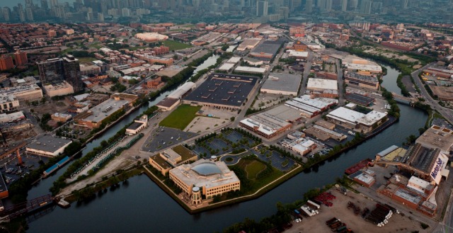
Fifty percent of land use is targeted for employment space under the latest proposal from the city’s Department of Planning and Development. The industrial corridor—which stretches from near Kinzie all the way past Fullerton, separating Bucktown from Lincoln Park, and encompassing all of Goose Island—is the first in line for the city’s ambitious review of its 26 industrial corridors; and the decisions that city planners ultimately put forth after the full public review period could point to how other such Planned Manufacturing Districts may be redrawn.
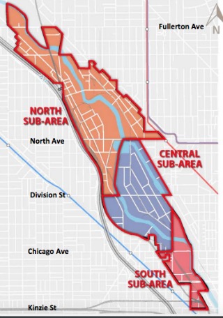 The summary of the framework plan presented to the public on Tuesday trisects the corridor into a North, Central and South Sub-Area. All areas allow for any existing uses to be maintained, but under the plan, each subset carries restrictions on what zoning transitions are allowed. Notably, the Central will not allow residential zoning. Mixed-used transitions (office, commercial and residential) will be accommodated on a case-by-case basis.
The corridor has grown substantially as a tech and information economy in recent years, moving further from its roots in industrial commerce.
Given the high percentage of land allotment to employment space and the potential to add up to 50 percent residential in two of the three Sub-Areas, some attendees at Tuesday’s meeting voiced anxiety about the relative lack of recreational and open space in the proposal—a misgiving that aldermen in attendance simultaneously supported and sought to assuage.
“This is a once-in-a-lifetime—if ever—opportunity to incorporate an industrial area into a residential area, and its really our only opportunity to get some usable open space both for the new residents… and for the residents we have,” said Ald. Michele Smith (43rd Ward), a vocal proponent for public space throughout the North Branch process. Smith’s ward in part borders the corridor.
“[I]f there is not actual recreational space—not just a river edge—the people who live there will simply come to out parks and will overrun [those facilities], which are already overburdened,” she added.
Ald. Brian Hopkins (2nd Ward) echoed that sentiment to the packed conference room. “We need to see open space and we need to see an increase in recreational space as part of this plan. [The planners] get it. They have heard us,” he said.
Hopkins also noted that he has yet to meet with Sterling Bay, the big-time real-estate developers who purchased the Finkl Steel site in December and intend to turn the 22-acre parcel into a mixed-use development of commercial, residential and retail property. How that development plays will likely significantly shape the outlook as well, especially the proposed extension of The 606.
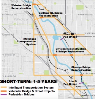 The summary did however have more specifics on another public-use aspect, as it offered intriguing transportation-access assessments. Short-term recommendations include pedestrian/bike bridges across the river, at Erie and Weed streets, plus the previously proposed reconstruction of the Division Street bridge, on either side of Goose Island.
Mid-term highlights include much-ballyhooed 606 Extension into Lincoln Park (which planners revealed would likely need to come from federal or state funds), a Blackhawk St. pedestrian bridge that would connect Bucktown to Goose Island and a major overhaul of the Chicago/Halsted viaduct.
One of the most notable long-term transit proposals is a pedestrian/bike transitway that would snake from south of Kinzie (near the river) up through Goose Island then run just west of the river all the way up to Armitage.
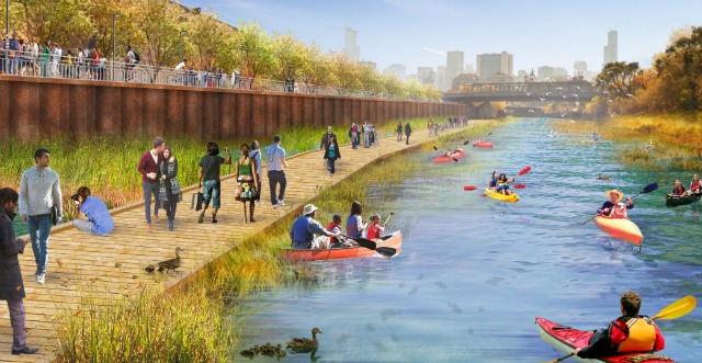
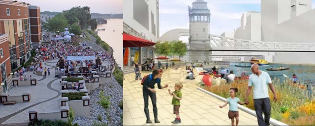
Planners also shared renderings of public riverwalk amenities, including a wetland park with boardwalk at the North Branch Canal.
The public comment continues for another 30 days, and more meetings are on the horizon: a community open house is scheduled for March 7 (8 a.m.) and March 14 (4 p.m.). The Department of Planning and Development looks to present its final plan to the Chicago Plan Commission in April or May. The City Council would have to approve an implementation ordinance in order to apply the framework.