The Best Places To Hike Around Chicago
By Emma G. Gallegos in Arts & Entertainment on Apr 6, 2017 5:42PM
Hiking around Chicago is like time-traveling. The land has been heavily shaped, scarred and preserved by the forces of prehistoric glaciers, agriculture, industry and conservationists of the state's unique ecology. It's not unusual to see all of these storylines converging on a single trail. You're bound to run into an old farmhouse or riverside mill powered by a glacial river, no matter where you are.
Two of the biggest projects to restore Illinois' tallgrass prairie occupy the same land as the Fermilab accelerator and an old army arsenal. You're never too far from history, but you can get away from the city to enjoy spring wildflowers, frozen waterfalls, grazing bison, towering dunes and lush forests along meandering rivers. We picked a list of the best places to hike, whether you want an edifying stroll on a paved path with historical markers, a climb to a vista or a traipse through dunes and brush.
A few words of warning for any trip to the outdoors: Always check the weather conditions, and call ahead or check online before you head out—Mother Nature can put a trail out of commission unexpectedly. Be prepared and bring plenty of food, water, sunscreen, bug spray and layers. And remember to leave no trace behind.
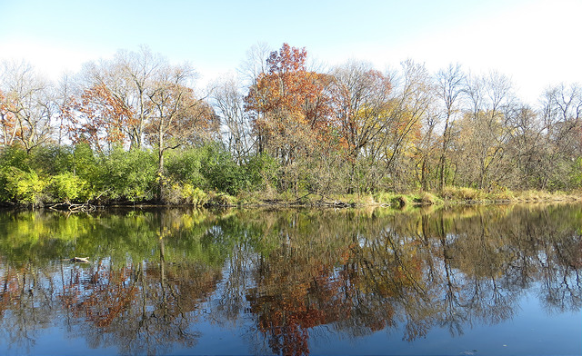
Fullersburg Woods in DuPage County (Photo by Debbie Mercer via the Chicagoist Featured Photos pool on Flickr)
FULLERSBURG WOODS
The Fullersburg Woods are a great place to go on a beautiful, easy hike—and also to learn a little about local history and fauna. The woods in Oak Brook are just a little over a half-hour from downtown. The wooded trails run alongside Salt Creek, a tributary of the Des Plaines river that features gentle falls. Depending on the season, you may find migratory birds warbling, here maple trees giving off sap or blooming wildflowers. There's a 2.2-mile multipurpose trail, a smaller interior loop that is 1.3 miles, and there is a short hikers-only shortcut called the Wildflower Trail.
Fullersburg Woods have a pretty great educational resources, especially for its size. The Nature Education Center has the remains of a 13,000-year-old wooly mammoth and year-round programming . At the southern end of the trail is a fully functioning historic mill that you can learn about in the Grau Mill and Museum. It was one of the "stations" of the Underground Railroad.
MORTON ARBORETUM
There are 16 miles of trails that criss-cross this "living laboratory" of thousands of trees in Lisle, about 40 minutes from downtown. Admission to Morton Arboretum is $14 for adults, which will grant you entrance onto the 1,700 acres of grounds that feature over 4,000 kinds of trees from around the world. (Annual passes are available, too.) You can spot deer and other wildlife, too, among the ponds, lakes, rivers, meadows, prairies and forests. Go for a gentle stroll around Meadow Lake or venture deeper into the property for hills and elevation. The Joy Path, named after the founder of both the arboretum and Morton Salt, has some nice views. Most of the trails are mulched or paved—but you can also trek off the beaten path. There's a PDF of the trails here. Enjoy some sustenance at the Gingko Cafe. The Arboretum is open year-round, and there's always lots of programming from 5Ks to winter lights. Starting in May, there will be origami in the gardens.
Another way to lose yourself in woods: Ryerson Woods
Midewin National Tallgrass Prairie (Photo by Bob Simpson via the Chicagoist Featured Photos pool on Flickr)
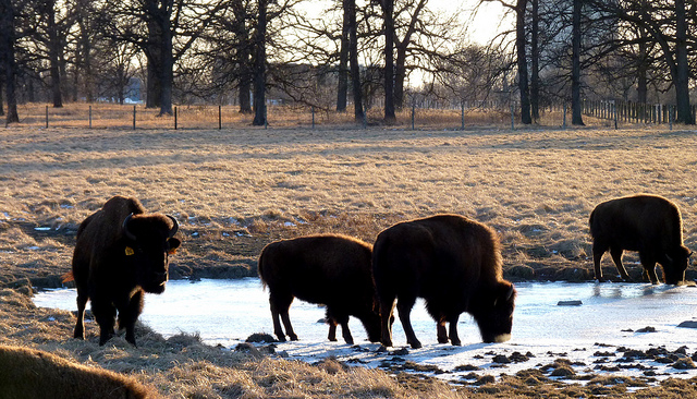
MIDEWIN NATIONAL TALLGRASS PRAIRIE
A funny thing about the Prairie State is that there is actually very little prairie left. Europeans transformed most of what was once tallgrass prairie in Illinois into farmland, but the U.S. Forest Service is trying to revert at least a small slice of the state back to its former glory. They're conducting something of an experiment on the 30 square miles of land between Wilmington and Joliet, at the former site of the U.S. Army Arsenal, which produced a billion tons of TNT during WWII. Now it's called the Midewin National Tallgrass Prairie, and it's home to 34 miles of hikes. A key part of the restoration project is a small herd of bison from Yellowstone in 2015 to add balance to the ecosystem, by attracting more species of birds, insects and plants while getting rid of invasive grasses. So far they've been very good at attracting humans.
There's no guarantee you'll see bison on any given day, but bring your binoculars and head to the Iron Bridge Trailhead and take the Group 63 Trail for your best chance. The southern half of the dirt trail takes you right up to the expansive fenced-in area where the bison graze. This 3.6-mile trail will take you past rows of bunkers where explosives were once stored. You can go inside and see workers' graffiti that includes drawings, profanity and even some good old shit-talking. This loop links up with the Twin Oaks Trail, which is a 6-mile loop, if you want a longer hike. Check the calendar, and you can get a guided ranger hike through October, a "ghost tour" of the arsenals or even a lecture on the health of the local bison. One word of caution for summertime hikers: by definition, there's very little shade on a prairie.
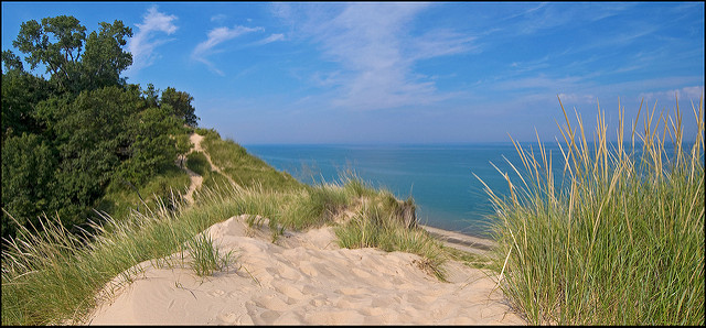
INDIANA DUNES NATIONAL LAKESHORE
There's more than just sand dunes at the Indiana Dunes National Lakeshore, just across the Lake from Chicago. The Cowles Bog Trail will give you a taste of a little bit of everything the Indiana shoreline has to offer, from prairie to lush, shaded wetlands to beach. The 4.7-mile lollipop-shaped trail begins in the marshy woodlands before you reach a loop that takes you to the shoreline dunes. On a clear day you can view the Chicago skyline. If the weather is right, this is a nice spot for a dip in the lake as well as a packed lunch. (Though you won't be able to shower off) The hike is moderate, though trekking up the dunes themselves at the midway point is on the strenuous side. The trail is named after Chicago botanist Henry Cowles, whose work studying the rich plant life you'll see on the trail like the black oak savanna, led to the Indiana Dunes being nationally protected. The Lakeshore boasts 50 miles of trails and the website has a long list of suggestions.
Other dunes: Warren Dunes State Park (Michigan), Indiana Dunes State Park
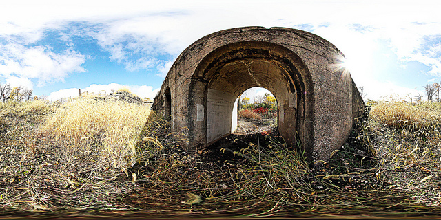
JOLIET IRON WORKS
If you like your hiking with a dose of gnarly post-industrial ruins, head to Joliet Iron Works. Once upon a time, it was home to one of the country's largest steel mills and thousands of workers, but it shut down by the 1980s. In the 1990s, the Forest Preserve District of Will County acquired the 52 acres of property. No buildings are left intact, but the foundation remains and it's pretty fascinating. There's a short paved trail that tells you the history of the factory and the ruins left behind, including the epic blast furnaces. The Joliet Iron Works site is also a great starting point to the limestone-paved Centennial Trail/I&M Canal Trail that runs over 10 miles north to the Cook County line to the Romeoville Prairie Nature Preserve.
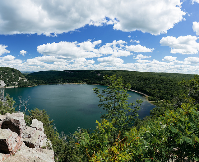
DEVIL'S LAKE
The Chicago area has a lot of pleasant strolls along prairies, forests, lakes, ponds and rivers. What it doesn't have are mountains or a whole a lot of elevation. If you're looking for a slightly more strenuous hike and some nice aerial views, you'll probably need to drive a little bit. Devil's Lake State Park just outside of Madison is a manageable journey (make a weekend of it!). There are steep bluffs on either side of the lake, and you'll be rewarded with gorgeous views at the top. The East Bluff and West Bluff trails are just about a mile and a half each, but you'll gain about 500 feet in elevation. Both will take you along the Ice Age Trail, which crosses through Wisconsin's glacier-shaped topography. The 1,000-mile trek trail is one of eight national scenic trails—and Baraboo Hills where Devil's Lake is one of the most scenic sections. There are several gentler hikes through the woods, too.
More bluffs: Castle Rock State Park
Other places to take in the Midwest's glacial history: Waterfall Glen, Moraine Hills
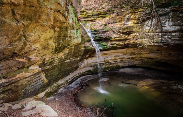
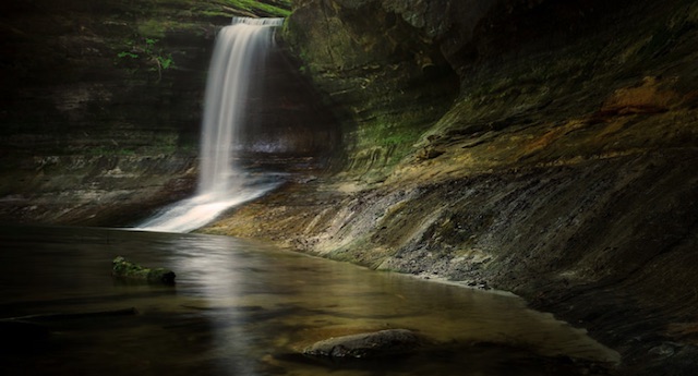
One of many waterfalls in the park (Photo by Ratul Maiti via the Chicagoist Featured Photos pool on Flickr)
STARVED ROCK STATE PARK
Little of the topography near Chicago is as dramatic as what you'll find at Starved Rock State Park. A prehistoric flood cut through soft St. Peter sandstone, creating gorgeous canyons and waterfalls that you can enjoy today. Spring is an especially good time to catch the waterfalls in action. There are 13 miles of trails along the banks of the Illinois River. If you want a full weekend getaway, you can camp or stay at the Starved Rock Lodge. Only 90 miles from the city, Starved Rock has been a big attraction since the 19th century, so it's no surprise that it attracts big crowds. There's a downside to that, including some hikers who have defaced the delicate sandstone. Don't be that jerk! And if you want to avoid the summertime crowds, the intricate frozen waterfalls in winter have their own beauty.
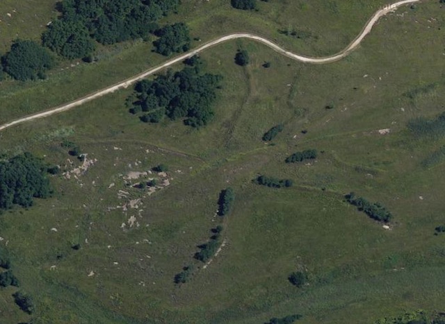
Michael Heizer's Effigy Tumuli (Google Earth)
BUFFALO ROCK STATE PARK
Just east of Starved Rock is Buffalo Rock State Park, a small park that is worth a stop for artist Michael Heizer's earth sculptures. "Effigy Tumuli" pays homage to the tradition of Native American mound building. The five sculptures, completed in 1985, each represent local animals: a catfish, a water strider, a frog, a turtle and a snake.
The Lower Dells in Matthiessen State Park (Photo by Ratul Maiti via the Chicagoist Featured Photos pool on Flickr)
MATTHIESSEN STATE PARK
Matthiessen State Park is the smaller, underrated neighbor of Starved Rock Creek Park. If you want to see stunning waterfalls and a river cutting through sandstone canyons but don't want to brave the crowds, head next door to Matthiessen, which runs alongside the Vermilion River (a tributary of the Illinois River that cuts through Starved Rock). The hiking routes aren't quite as polished—the trails are a little rougher and there are a lot of stairs—but the canyonscapes and falls are just as breathtaking.
Even more riverside hiking with canyons and waterfalls: Kankakee River State Park
FERMILAB
Fermilab isn't just the site of major discoveries about the fabric of reality and a really, really big magnet. It's also a lovely place in the Western burbs to enjoy a restored slice of the tallgrass prairie that once dominated Illinois. As with Midewin, native seedlings have been planted, and a herd of grazing bison and barn owls brought in from the outside have made their home here. You can access the Prairie Trails, including a quarter-mile interpretive trail, most easily through the Main Entrance on the Western side of the campus. (Be warned you'll have to flash a photo ID to a security guard.) There's a three-mile path that runs from one end of the campus to another, but a couple years ago Fermilab opened some new loops for both bikers and walkers. Some things you might see along the route include some pretty cool architecture and sculptures and barns (that host barn-dancing!).
Yet another place to see bison: Nachusa Grasslands