City Finalizes Plan For 700-Acre North Branch Site & Extension Of The 606
By Stephen Gossett in News on May 9, 2017 4:00PM


The massively ambitious redevelopment framework for a large, North Side parcel of land was finalized on Monday evening. After months of community input—including a not-insignificant amount of skepticism over certain details—the City of Chicago and the Department of Planning and Development officially put forth the final draft of the North Branch Industrial Corridor Framework—which lays the groundwork for some of the most dramatic urban-environment revamps the city has seen in recent years. It's a major push away from the site's industrial past into a future that foresees, among other things, an expansion of The 606, new residential development, and (in no small measures) major new business and tech options.
The changes portended by the finalized plan are hard to overstate for the 700-plus-acre corridor—even if, after so much discussion, mostly expected. Like previous drafts, the finalized plan for North Branch—which stretches from near Kinzie all the way past Fullerton, separating Bucktown from Lincoln Park, and encompasses all of Goose Island—targets more than half of the corridor for business and employment. But it also includes major transportation, residential and open space changes.
If you haven't been following along from the beginning, the most significant redevelopment effort within the parcel would likely see the old Finkl Steel site transformed. Developers Sterling Bay bought the 40-acre parcel for $140 million last year and, if zoning changes go through, it could open up for a mixed-used mega-development of sorts. The surrounding area's already-in-progress transformation into a tech and information-economy hub could accelerate and spread. Under Sterling Bay, the Finkl space could also serve as anchor for the 606 expansion.
Many residents and aldermen had balked that previous drafts short-shrifted desperately-needed park space in favor of business interests. That fight culminated when Ald. Brian Hopkins (2nd Ward), Scott Waguespack (32nd) and Michele Smith (43rd Ward) and various community groups sent a letter to the Department of Planning and Development demanding more continuous park space. Good news for green-space fans, the DPD acquiesced, to a degree: A floor of "no less than” 10 new acres will be dedicated to various open-space use, including ball fields and playgrounds.
“As you know, I’ve advocated from the beginning of the process that we accommodate open space needs for our community," said Hopkins in a release. "While I recently noted objections and concerns to the open space treatment in the Modernization plan, I’m encouraged that there’s been a recognition to accommodate the needs of neighbors and young families in nearby, impacted neighborhoods."
Smith told Chicagoist that she is "pleased that city has set a goal to serving the needs of some residents by establishing a floor, but we're not done." She said the plan still lacks a mechanism for how the acreage will be incorporated and puts the onus on developers.
Open space use breaks down like this, per the City of Chicago:
- Build 32 acres of linear park space as part of a new, seven-mile river trail, consistent with Mayor Emanuel’s vision of enhancing the river as Chicago’s next recreational frontier
- Incorporate at least 10 acres of new publicly accessible open spaces for sports and recreational fields
- Add a one-acre park as part of The 606's connection with the river trail
- Create 17 acres of wetland parks
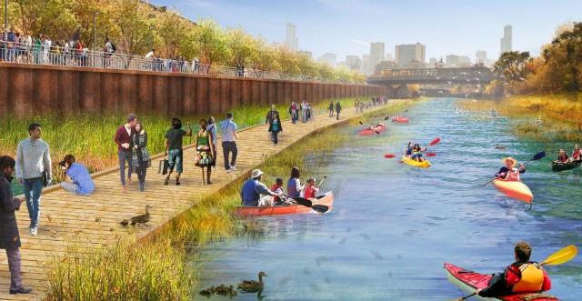
As for transportation, the sexy headline remains the expansion of The 606, the popular rail-to-trail path that's now positioned to push into Lincoln Park—and potentially, one day, even further east.
The planning department writes:
A new North Branch trail system would enhance area connectivity between West Town, Logan Square, Lincoln Park and the Near North Side by connecting to the recently completed 606 multi-purpose path that terminates near the corridor’s western boundary. The portion of the connection on underutilized land below the Kennedy Expressway could include an active recreational area.
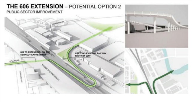
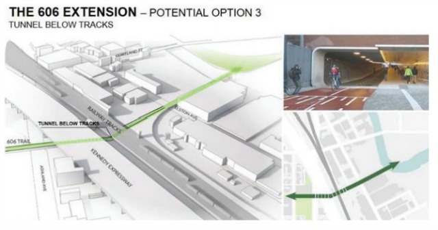
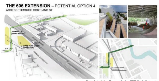
The exact nature of the expansion is still up in the air. Development plans and aldermen's and constituents' concerns will surely shape its future. But the framework—as in previous drafts—does propose four preliminary options, including a Cortland path and a tunnel.

Further transportation changes include reconfigured roads and bridges (including the Chicago/Halsted viaduct) and a dozen new pedestrian/bike bridges and "under-bridge connections" along the river.
The question of how much residential allotment was another point of debate in finalizing the plan. The finalized draft again trisects the overall corridor into three sections: the north section will allow transitions to that include residential—along with commercial and mixed-used "at appropriate locations;" the central does not allow for residential use; and the south section would make for zoning changes that include mixed-use and residential.
The long-debated overhaul outlined in the plan is indeed sweeping, but it also carries implications far beyond the the North Branch borders. The framework represents just the first step in a massive review of the city's 26 total industrial corridors—which could see other Planned Manufacturing Districts, if given proper rezoning, give way to similar combos of new parks, transportation infrastructure, residential development and commerce. (Remember, with 50-plus percent the North Branch aimed for "employment purposes," the onus was still largely on industry.)
The next step for the now-finalized framework is a review by the Chicago Plan Commission, on May 18.